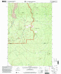
1998 Map of King Mountain
USGS Topo · Published 2003About this map
The Yakama Indian Reservation boundary winds through this mountainous terrain, meeting the eastern edge of the Gifford Pinchot National Forest. This 1998 revision of the landscape captures a transition from the volcanic features of the Aiken Lava Bed to the high peaks of King Mountain and Snowplow Mountain. The map reflects the region's development as a winter recreation hub, documenting several organized staging areas including Smith Butte Sno-Park, Gotchen Creek Sno-Park, and Pipeline Sno-Park. Local drainage patterns are defined by Gotchen Creek and Indian Creek, while industrial activity is noted at the southern edge with a Gravel Pit and Cinder Pit. This survey provides a clear look at the intersecting forest management and tribal land boundaries at the turn of the millennium.
Find a feature on this map
24 named features on this map. Tap any name to fly to it.
Don’t see what you’re looking for? This feature index may not catch every label — zoom into the map to look around manually.
Map Details
Editions of this 1998 King Mountain Map
This is the sole edition of this map. No revisions or reprints were ever made.
Other maps of this area

1904 · Mount Adams
USGS Topo · 1:125,000

1907 · Mount Adams
USGS Topo · 1:125,000

1926 · Steamboat Mtn
USGS Topo · 1:125,000

1926 · Hood River
USGS Topo · 1:125,000

1929 · Hood River
USGS Topo · 1:125,000

1931 · Steamboat Mtn
USGS Topo · 1:125,000

1934 · The Dalles
USGS Topo · 1:125,000

1950 · Yakima
USGS Topo · 1:250,000

1953 · The Dalles
USGS Topo · 1:250,000

1956 · The Dalles
USGS Topo · 1:250,000