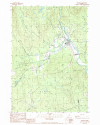
1989 Map of Kingfield
USGS Topo · Published 1989About this map
The Carrabassett River flows through the heart of Kingfield, anchoring a landscape where timber and water resources define the local economy in the late 1980s. This survey illustrates the settlement's concentrated core near the river's bend, while the surrounding terrain rises sharply toward Vose Mountain and Foster Hill. The presence of Soule Mill along the West Branch Stream indicates a persistent industrial tie to the region's forests, supplemented by numerous gravel pits that suggest active infrastructure and resource extraction at this time.
Find a feature on this map
29 named features on this map. Tap any name to fly to it.
Don’t see what you’re looking for? This feature index may not catch every label — zoom into the map to look around manually.
Map Details
Editions of this 1989 Kingfield Map
This is the sole edition of this map. No revisions or reprints were ever made.
Other maps of this area

1928 · Dead River
USGS Topo · 1:62,500

1928 · Stratton
USGS Topo · 1:48,000

1929 · Phillips
USGS Topo · 1:48,000

1930 · Kingfield
USGS Topo · 1:48,000

1931 · Dead River
USGS Topo · 1:48,000

1932 · Phillips
USGS Topo · 1:62,500

1932 · Stratton
USGS Topo · 1:62,500

1932 · Kingfield
USGS Topo · 1:62,500

1944 · Dead River
USGS Topo · 1:62,500

1949 · Jackman
USGS Topo · 1:250,000