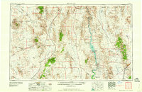
1960 Map of Kingman
USGS Topo · Published 1960About this map
The Colorado River corridor anchors this mid-century look at the tri-state borderlands, featuring the massive impoundments at Hoover Dam and Davis Dam that created Lake Mead National Recreational Area and Lake Mohave. The landscape is a study in desert industry and infrastructure, from the mining operations at Lucky Dutchman Mine and King T-1 Mine to the critical rail links of the Union Pacific and Atchison Topeka and Santa Fe.
Find a feature on this map
82 named features on this map. Tap any name to fly to it.
Don’t see what you’re looking for? This feature index may not catch every label — zoom into the map to look around manually.
Map Details
Editions of this 1960 Kingman Map
3 editions found

Other maps of this area

1886 · Diamond Creek
USGS Topo · 1:250,000

1886 · Camp Mohave
USGS Topo · 1:250,000

1886 · Saint Thomas
USGS Topo · 1:250,000

1886 · Mt. Trumbull
USGS Topo · 1:250,000

1892 · Diamond Creek
USGS Topo · 1:250,000

1892 · Mt. Trumbull
USGS Topo · 1:250,000

1892 · Camp Mohave
USGS Topo · 1:250,000

1893 · Saint Thomas
USGS Topo · 1:250,000

1903 · Needles
USGS Topo · 1:125,000

1904 · Needles Special
USGS Topo · 1:125,000