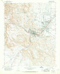
1967 Map of Kingman
USGS Topo · Published 1968About this map
Kingman serves as the focal point of this mid-century desert landscape, situated at the junction where the Sacramento Valley meets the rising slopes of the Cerbat Mountains and Hualapai Mountains. The town's infrastructure reflects its role as a transportation hub, with the Atchison Topeka and Santa Fe RR curving through the terrain alongside established neighborhoods like Hilltop and industrial sidings at Getz. Evidence of post-war community growth is visible in the presence of the Manganita Sch, Palo Christi Sch, and the local County Fairgrounds.
Find a feature on this map
48 named features on this map. Tap any name to fly to it.
Don’t see what you’re looking for? This feature index may not catch every label — zoom into the map to look around manually.
Map Details
Editions of this 1967 Kingman Map
2 editions found
Other maps of this area

1886 · Diamond Creek
USGS Topo · 1:250,000

1886 · Camp Mohave
USGS Topo · 1:250,000

1892 · Diamond Creek
USGS Topo · 1:250,000

1892 · Camp Mohave
USGS Topo · 1:250,000

1939 · Chloride
USGS Topo · 1:48,000

1942 · Camp Mohave
USGS Topo · 1:250,000

1944 · Chloride
USGS Topo · 1:62,500

1947 · Kingman
USGS Topo · 1:250,000

1948 · Kingman
USGS Topo · 1:250,000

1948 · Williams
USGS Topo · 1:250,000