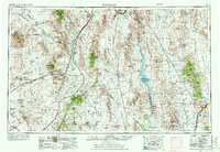
1954 Map of Kingman
USGS Topo · Published 1972About this map
Lake Mohave and the winding Colorado River serve as the central artery for this tri-state region where Arizona, California, and Nevada converge. The 1954 data illustrates a landscape defined by industrial transit and water management, anchored by the planned community of Boulder City and the burgeoning desert crossroads of Kingman. Infrastructure is prominently mapped, including the major corridors of U.S. Highway 66 and U.S. Highway 91 & 466, which facilitated mid-century westward migration and tourism.
Find a feature on this map
65 named features on this map. Tap any name to fly to it.
Don’t see what you’re looking for? This feature index may not catch every label — zoom into the map to look around manually.
Map Details
Editions of this 1954 Kingman Map
4 editions found

Other maps of this area

1886 · Diamond Creek
USGS Topo · 1:250,000

1886 · Camp Mohave
USGS Topo · 1:250,000

1886 · Saint Thomas
USGS Topo · 1:250,000

1886 · Mt. Trumbull
USGS Topo · 1:250,000

1892 · Diamond Creek
USGS Topo · 1:250,000

1892 · Mt. Trumbull
USGS Topo · 1:250,000

1892 · Camp Mohave
USGS Topo · 1:250,000

1893 · Saint Thomas
USGS Topo · 1:250,000

1903 · Needles
USGS Topo · 1:125,000

1904 · Needles Special
USGS Topo · 1:125,000