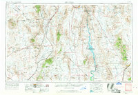
1954 Map of Kingman
USGS Topo · Published 1968About this map
The Colorado River carves a critical boundary through the center of this Mojave Desert landscape, marking the divide between Nevada, California, and Arizona. Just over a decade after the completion of the Hoover Dam, the region exhibits a shift from isolated mining outposts to an infrastructure-driven economy, anchored by Boulder City and the newly formed Lake Mead National Recreational Area. The mapping of Lake Mohave and the Davis Dam Spillway 597 highlights the mid-century transformation of the river for power and recreation.
Find a feature on this map
154 named features on this map. Tap any name to fly to it.
Don’t see what you’re looking for? This feature index may not catch every label — zoom into the map to look around manually.
Map Details
Editions of this 1954 Kingman Map
4 editions found

Other maps of this area

1886 · Diamond Creek
USGS Topo · 1:250,000

1886 · Camp Mohave
USGS Topo · 1:250,000

1886 · Saint Thomas
USGS Topo · 1:250,000

1886 · Mt. Trumbull
USGS Topo · 1:250,000

1892 · Diamond Creek
USGS Topo · 1:250,000

1892 · Mt. Trumbull
USGS Topo · 1:250,000

1892 · Camp Mohave
USGS Topo · 1:250,000

1893 · Saint Thomas
USGS Topo · 1:250,000

1903 · Needles
USGS Topo · 1:125,000

1904 · Needles Special
USGS Topo · 1:125,000