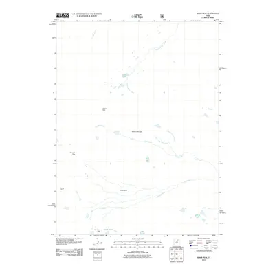
2011 Map of Kings Peak
USGS Topo · Published 2011About this map
Kings Peak and Gilbert Peak dominate this high-elevation terrain in Summit County, providing a clear view of the hydrological divide where several major water systems originate. The drainage patterns are defined by the Gilbert Creek Basin, which feeds into Gilbert Creek via its Center Fork Gilbert Creek and North Fork Gilbert Creek tributaries. To the south, the Uinta River flows through the expansive Painter Basin, surrounded by a series of alpine lakes including Lake George Beard, Lake Atwood, and the Painter Lakes. Historical movement through this high country is marked by topographic bottlenecks such as Gunsight Pass and Trail Rider Pass, which have long served as primary corridors for those navigating the region's steep gradients and glacial lake basins.
Find a feature on this map
17 named features on this map. Tap any name to fly to it.
Don’t see what you’re looking for? This feature index may not catch every label — zoom into the map to look around manually.
Map Details
Editions of this 2011 Kings Peak Map
This is the sole edition of this map. No revisions or reprints were ever made.
Other maps of this area

1885 · Uinta
USGS Topo · 1:250,000

1905 · Gilbert Peak
USGS Topo · 1:125,000

1906 · Gilbert Peak
USGS Topo · 1:125,000

1954 · Salt Lake City
USGS Topo · 1:250,000

1958 · Salt Lake City
USGS Topo · 1:250,000

1960 · Salt Lake City
USGS Topo · 1:250,000

1965 · Mount Emmons
USGS Topo · 1:24,000
1965 · Kings Peak
USGS Topo · 1:24,000
1965 · Bollie Lake
USGS Topo · 1:24,000
1965 · Fox Lake
USGS Topo · 1:24,000