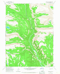
1965 Map of Bollie Lake
USGS Topo · Published 1967About this map
The Uinta River carves a deep path through this high-altitude landscape within the Ashley National Forest, serving as the primary corridor for movement. In the mid-1960s, human presence was defined by the Uinta River Pack Trail and the seasonal activities at the U-Bar Ranch. The map reveals a network of high-country water bodies, from Bollie Lake and Lower Chain Lake in the west to Wild Goose Lake and Meadow Lake in the east. Infrastructure in this wilderness area is sparse, concentrated near the river at sites like the Uinta Park Guard Station and the Wandin Campground. Crossings such as the Sheep Bridge and Rock Canyon Bridge show how travelers navigated the steep terrain of Rock Canyon and its tributaries. This survey preserves a moment before modern development, where transit relied heavily on pack trails and a single Jeep Trail.
Find a feature on this map
30 named features on this map. Tap any name to fly to it.
Don’t see what you’re looking for? This feature index may not catch every label — zoom into the map to look around manually.
Map Details
Editions of this 1965 Bollie Lake Map
This is the sole edition of this map. No revisions or reprints were ever made.
Other maps of this area

1885 · Uinta
USGS Topo · 1:250,000

1905 · Gilbert Peak
USGS Topo · 1:125,000

1906 · Gilbert Peak
USGS Topo · 1:125,000

1954 · Salt Lake City
USGS Topo · 1:250,000

1958 · Salt Lake City
USGS Topo · 1:250,000

1960 · Salt Lake City
USGS Topo · 1:250,000
1965 · Rasmussen Lakes
USGS Topo · 1:24,000
1965 · Pole Creek Cave
USGS Topo · 1:24,000

1965 · Mount Emmons
USGS Topo · 1:24,000
1965 · Heller Lake
USGS Topo · 1:24,000