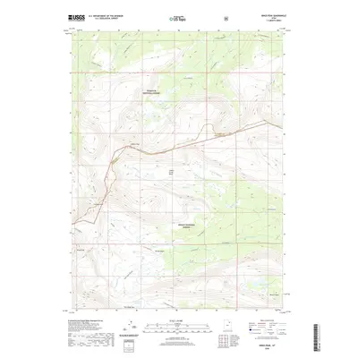
2020 Map of Kings Peak
USGS Topo · Published 2020About this map
Kings Peak stands as the primary landmark of this high-elevation terrain along the border of Summit and Duchesne counties. The landscape is dominated by the transition between the Wasatch National Forest and the Ashley National Forest, showcasing a network of alpine basins and water bodies including Gilbert Lake, Milk Lake, and Lake George Beard. Major drainage systems like the Uinta River and various forks of Gilbert Creek define the eastern slope. The map details an extensive high-country trail network, most notably the Uinta Highline trail and the Chain Lakes-Atwood route, which navigate through critical points such as Gunsight Pass, Trail Rider Pass, and Painter Basin. This survey provides a precise accounting of the watershed and topography surrounding Utah's highest elevations in the early twenty-first century.
Find a feature on this map
24 named features on this map. Tap any name to fly to it.
Don’t see what you’re looking for? This feature index may not catch every label — zoom into the map to look around manually.
Map Details
Editions of this 2020 Kings Peak Map
This is the sole edition of this map. No revisions or reprints were ever made.
Other maps of this area

1885 · Uinta
USGS Topo · 1:250,000

1905 · Gilbert Peak
USGS Topo · 1:125,000

1906 · Gilbert Peak
USGS Topo · 1:125,000

1954 · Salt Lake City
USGS Topo · 1:250,000

1958 · Salt Lake City
USGS Topo · 1:250,000

1960 · Salt Lake City
USGS Topo · 1:250,000

1965 · Mount Emmons
USGS Topo · 1:24,000
1965 · Kings Peak
USGS Topo · 1:24,000
1965 · Bollie Lake
USGS Topo · 1:24,000
1965 · Fox Lake
USGS Topo · 1:24,000