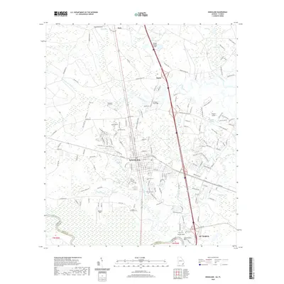
2020 Map of Kingsland
USGS Topo · Published 2020About this map
Kingsland and the outskirts of ST. Marys serve as the primary anchors of this coastal Georgia corridor just north of the Florida state line. The landscape is defined by the winding course of the Saint Marys River and an extensive network of wetlands, including Seals Swamp, Shingle Swamp, and Caney Swamp. This 2020 record illustrates the modern integration of heavy transportation infrastructure, such as Interstate 95, with a rural heritage preserved in numerous family and community burial grounds like Zion Cem, Peeples Cem, and Sheffield Cem. Smaller settlements such as Kinlaw and Seals sit amidst a complex hydrology of creeks like Catfish Creek and May Creek, where higher ground is often named as islands or bluffs, including Shingle Swamp Island and Griffin Bluff. The map provides a detailed view of how residential expansion around Kingsland interfaces with the dense swamp land of the coastal plain.
Find a feature on this map
163 named features on this map. Tap any name to fly to it.
Don’t see what you’re looking for? This feature index may not catch every label — zoom into the map to look around manually.
Map Details
Editions of this 2020 Kingsland Map
This is the sole edition of this map. No revisions or reprints were ever made.
Other maps of this area

1917 · Boulogne
USGS Topo · 1:62,500

1917 · Hilliard
USGS Topo · 1:62,500

1918 · St Marys
USGS Topo · 1:62,500

1918 · Kingsland
USGS Topo · 1:62,500

1919 · St Marys
USGS Topo · 1:62,500

1919 · Hilliard
USGS Topo · 1:62,500

1919 · Boulogne
USGS Topo · 1:62,500

1948 · Jacksonville
USGS Topo · 1:250,000

1957 · Jacksonville
USGS Topo · 1:250,000

1958 · Gross
USGS Topo · 1:24,000