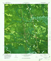
1980 Map of Kingsland
USGS Topo · Published 1980About this map
The salt marshes and coastal forests of Camden County define this orthophotomap, which merges traditional topographic data with aerial photography. In the center of the sheet, the community of Seals serves as a local landmark along the rail lines and wetlands. Further north, the settlement of Kinlaw sits near the winding estuaries and creek systems that characterize the Georgia coast. This 1974-based photo-revised survey highlights the transition between the developed coastal corridors and the dense, swampy vegetation of the Lowcountry. The inclusion of photographic imagery allows for a precise view of the vegetation patterns and water channels that historically supported the regional timber and fishing economies before later 20th-century development altered the landscape.
Find a feature on this map
2 named features on this map. Tap any name to fly to it.
Don’t see what you’re looking for? This feature index may not catch every label — zoom into the map to look around manually.
Map Details
Editions of this 1980 Kingsland Map
This is the sole edition of this map. No revisions or reprints were ever made.
Other maps of this area

1917 · Boulogne
USGS Topo · 1:62,500

1917 · Hilliard
USGS Topo · 1:62,500

1918 · St Marys
USGS Topo · 1:62,500

1918 · Kingsland
USGS Topo · 1:62,500

1919 · St Marys
USGS Topo · 1:62,500

1919 · Hilliard
USGS Topo · 1:62,500

1919 · Boulogne
USGS Topo · 1:62,500

1948 · Jacksonville
USGS Topo · 1:250,000

1957 · Jacksonville
USGS Topo · 1:250,000

1958 · Gross
USGS Topo · 1:24,000