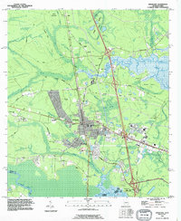
1993 Map of Kingsland
USGS Topo · Published 1995About this map
Kingsland sits at a critical junction of southern Georgia geography, where the St Marys Railroad and major Interstate interchanges meet the winding wetlands of the St Marys River. This 1993 revision documents a landscape in transition, where established family landmarks like Sheffield Cem and Brazell Cem share the map with modern developments and several mobile home parks. The area’s spiritual and educational roots are well-represented by Carnegie Chapel, Evergreen Ch, and the Matilda Harris Sch. To the north and east, the terrain yields to the tidal influence of the Crooked River and Shingle Island Swamp, while local industry is noted by several sandpits near Colerain RD. The map captures the distinct boundary between Camden Co and Nassau Co, marking the interstate line between Georgia and Florida.
Find a feature on this map
58 named features on this map. Tap any name to fly to it.
Don’t see what you’re looking for? This feature index may not catch every label — zoom into the map to look around manually.
Map Details
Editions of this 1993 Kingsland Map
This is the sole edition of this map. No revisions or reprints were ever made.
Other maps of this area

1917 · Boulogne
USGS Topo · 1:62,500

1917 · Hilliard
USGS Topo · 1:62,500

1918 · St Marys
USGS Topo · 1:62,500

1918 · Kingsland
USGS Topo · 1:62,500

1919 · St Marys
USGS Topo · 1:62,500

1919 · Hilliard
USGS Topo · 1:62,500

1919 · Boulogne
USGS Topo · 1:62,500

1948 · Jacksonville
USGS Topo · 1:250,000

1957 · Jacksonville
USGS Topo · 1:250,000

1958 · Gross
USGS Topo · 1:24,000