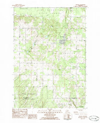
1983 Map of Kingsley
USGS Topo · Published 1984About this map
Kingsley and Summit City anchor this landscape during the early 1980s, where the Michigan Northern Railroad corridors define the local transportation network. The area is characterized by a mix of agricultural plots and protected timberland within the Pere Marquette State Forest. Notable for genealogists are the distribution of local burial grounds, including Barnum Cem, Evergreen Cem, and Blackman Cem, alongside community landmarks like Gleaner Hall and Kingdom Hall. The terrain is shaped by water features such as the Weidenhamer Swamp and Big Marsh, which are drained by a system of creeks including Jaxon Creek and Swainston Creek. This survey captures the rural character of Grand Traverse County before modern suburban expansion, preserving the grid of roads like Slocum Road and Walton Road that connected these small hubs to the outlying Mayfield and Baxter settlements.
Find a feature on this map
44 named features on this map. Tap any name to fly to it.
Don’t see what you’re looking for? This feature index may not catch every label — zoom into the map to look around manually.
Map Details
Editions of this 1983 Kingsley Map
This is the sole edition of this map. No revisions or reprints were ever made.
Other maps of this area

1954 · Traverse City
USGS Topo · 1:250,000

1956 · Fife Lake
USGS Topo · 1:62,500

1956 · Kingsley
USGS Topo · 1:62,500

1956 · Mesick
USGS Topo · 1:62,500

1956 · Cadillac North
USGS Topo · 1:62,500

1958 · Traverse City
USGS Topo · 1:250,000

1983 · Cadillac
USGS Topo · 1:100,000

1983 · Manton
USGS Topo · 1:25,000

1983 · Buckley
USGS Topo · 1:25,000

1983 · Traverse City
USGS Topo · 1:100,000
Featured Places
- Blair Township, MI
- Paradise Township, MI
- Mayfield Township, MI
- Kingsley, Paradise Township
- Hanover Township, MI