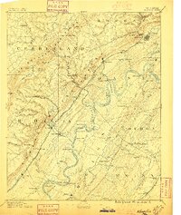
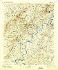
1891 Map of Kingston
USGS Topo · Published 1891About this map
Kingston and the surrounding river valleys are captured here in the late 19th century, a landscape defined by the serpentine path of the Tennessee River and its meeting with the Clinch River and Emory River. The region reflects a transition from river-based transport to the industrial era, with numerous crossings like Mc Elwee's Ferry and Seviers Ferry still serving as vital links while the Cincinnati Southern Railroad and the Tennessee and Sequatchee Valley Railroad push through the terrain. The map documents early community hubs such as Kemmers Old Stand and Rhea Springs, alongside the nascent industrial developments at Rockwood and Cardiff. High points like the Cumberland Mountains and Crab Orchard Mountains loom over the valleys, where localized settlements like Post Oak Springs and Glen Alice are firmly established.
Find a feature on this map
126 named features on this map. Tap any name to fly to it.
Don’t see what you’re looking for? This feature index may not catch every label — zoom into the map to look around manually.
Map Details
Editions of this 1891 Kingston Map
2 editions found