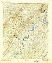
1893 Map of Kingston
USGS Topo · Published 1938About this map
The Tennessee River snakes through the heart of this landscape, its deep bends defining the geography of the late nineteenth century. At this time, the river served as a vital transit artery, marked by numerous crossings such as McElwee Ferry, Jackson Ferry, and Sewer Ferry. To the west, the Cumberland Plateau rises sharply, punctuated by unique geological features like the Sinks Grassy Cove and the high peaks of Luper Mt.
Find a feature on this map
128 named features on this map. Tap any name to fly to it.
Don’t see what you’re looking for? This feature index may not catch every label — zoom into the map to look around manually.
Map Details
Editions of this 1893 Kingston Map
5 editions found
Other maps of this area

1886 · Cleveland
USGS Topo · 1:125,000

1887 · Kingston
USGS Topo · 1:125,000

1888 · Chattanooga
USGS Topo · 1:125,000

1891 · Kingston
USGS Topo · 1:125,000

1892 · Pikeville
USGS Topo · 1:125,000

1892 · Cleveland
USGS Topo · 1:125,000

1893 · Chattanooga
USGS Topo · 1:125,000

1893 · Murphy
USGS Topo · 1:125,000

1893 · Briceville
USGS Topo · 1:125,000

1893 · Kingston
USGS Topo · 1:125,000