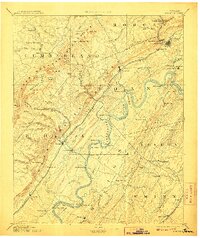
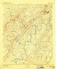
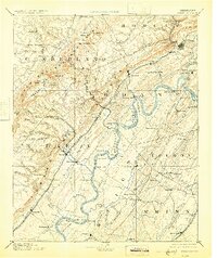
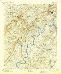
1893 Map of Kingston
USGS Topo · Published 1907About this map
The confluence of the Clinch River and the Tennessee River at Kingston anchors this late-19th-century study of the eastern Cumberland Plateau. The landscape is defined by the sharp transition from the river valleys to the high Escarpment, where industrial hubs like Rockwood and Harriman emerged at the intersection of water and rail. The arrival of the Cincinnati Southern Railroad and the Tennessee and Sequatchee Valley Railroad through Emory Gap signaled a shift toward coal and iron transport, though the region remained deeply tied to the river economy. Numerous landings and river crossings, such as McElwee Ferry and Jackson Ferry, suggest a time when river transport was essential for reaching isolated settlements like Euchee and Ten Mile Stand. To the west, the map details the unique geology of Grassy Cove and Swagerty Cove, natural depressions within the plateau that supported early agrarian communities.
Find a feature on this map
134 named features on this map. Tap any name to fly to it.
Don’t see what you’re looking for? This feature index may not catch every label — zoom into the map to look around manually.
Map Details
Editions of this 1893 Kingston Map
5 editions found
Other maps of this area

1886 · Cleveland
USGS Topo · 1:125,000

1887 · Kingston
USGS Topo · 1:125,000

1888 · Chattanooga
USGS Topo · 1:125,000

1891 · Kingston
USGS Topo · 1:125,000

1892 · Pikeville
USGS Topo · 1:125,000

1892 · Cleveland
USGS Topo · 1:125,000

1893 · Chattanooga
USGS Topo · 1:125,000

1893 · Murphy
USGS Topo · 1:125,000

1893 · Briceville
USGS Topo · 1:125,000

1893 · Kingston
USGS Topo · 1:125,000