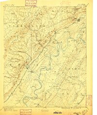
1891 Map of Kingston
USGS Topo · Published 1896About this map
The Tennessee River winds through the heart of this East Tennessee landscape, serving as a vital artery long before modern bridges replaced the numerous river crossings shown here. A dense network of transport is evident, from the Sewer Ferry and McElwee Ferry to the industrial spine of the Cincinnati Southern Railroad and the Tennessee and Sequatchee Valley Railroad. The terrain is dominated by the Cumberland Escarpment and the Crab Orchard Mountains, where unique geologic features like Grassy Cove and Swagerty Cove break the ridge lines.
Find a feature on this map
130 named features on this map. Tap any name to fly to it.
Don’t see what you’re looking for? This feature index may not catch every label — zoom into the map to look around manually.
Map Details
Editions of this 1891 Kingston Map
2 editions found
Other maps of this area

1886 · Cleveland
USGS Topo · 1:125,000

1887 · Kingston
USGS Topo · 1:125,000

1888 · Chattanooga
USGS Topo · 1:125,000

1891 · Kingston
USGS Topo · 1:125,000

1892 · Pikeville
USGS Topo · 1:125,000

1892 · Cleveland
USGS Topo · 1:125,000

1893 · Chattanooga
USGS Topo · 1:125,000

1893 · Murphy
USGS Topo · 1:125,000

1893 · Briceville
USGS Topo · 1:125,000

1893 · Kingston
USGS Topo · 1:125,000