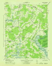
1943 Map of Kingston
USGS Topo · Published 1943About this map
Westover and Kingston anchor this wartime survey of Somerset County, where the Pennsylvania Railroad Crisfield Branch cuts through the lowlands of the Eastern Shore. The landscape is defined by its rural density, featuring a high concentration of country churches including St Pauls Church, St Marks Church, and Quindooqua Church. To the east, the terrain transitions into the dense Cypress Swamp as it approaches the banks of the Pocomoke River. Small settlements and landmarks like Cottage Grove and Hudson Corner illustrate the intersection of agricultural land and coastal drainage systems like the Big Annemessex River. The inclusion of election districts such as Westover No 13 and Brinkleys No 3 provides a clear framework for local genealogists tracing family locations across this tidal landscape during the early 1940s.
Find a feature on this map
37 named features on this map. Tap any name to fly to it.
Don’t see what you’re looking for? This feature index may not catch every label — zoom into the map to look around manually.
Map Details
Editions of this 1943 Kingston Map
This is the sole edition of this map. No revisions or reprints were ever made.
Other maps of this area

1903 · Crisfield
USGS Topo · 1:62,500

1903 · Deal Island
USGS Topo · 1:62,500

1920 · Crisfield
USGS Topo · 1:62,500

1942 · Marion
USGS Topo · 1:24,000

1942 · Monie
USGS Topo · 1:24,000

1942 · Kingston
USGS Topo · 1:24,000

1942 · Princess Anne
USGS Topo · 1:24,000

1942 · Saxis
USGS Topo · 1:24,000

1942 · Dividing Creek
USGS Topo · 1:24,000

1943 · Dividing Creek
USGS Topo · 1:31,680