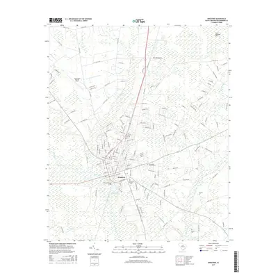
2017 Map of Kingstree
USGS Topo · Published 2017About this map
The Black River winds past the historic settlement of Kingstree, serving as a central geographic anchor for this part of Williamsburg County. The landscape is characterized by a high density of wetlands and named bays, including Findley Bay, Lower Rutledge Bay, and the extensive Whiteoak Swamp. These features indicate the low-lying, hydrologically complex nature of the coastal plain. In the town center, the Williamsburg Technical Coll and Williamsburg Presbyterian Cem stand as significant local landmarks, while the Wallace D Conner Bridge provides a vital crossing over the river. Outside the main town, the smaller community of Brockington and the Williamsburg Regional Airport highlight the area's ongoing development. For those tracing family history, the presence of the McClary Cem and numerous named roads like Wilson Chapel Rd and Sandy Bay Rd offer specific points of interest for identifying 21st-century property locations and community centers.
Find a feature on this map
133 named features on this map. Tap any name to fly to it.
Don’t see what you’re looking for? This feature index may not catch every label — zoom into the map to look around manually.
Map Details
Editions of this 2017 Kingstree Map
This is the sole edition of this map. No revisions or reprints were ever made.
Other maps of this area

1946 · Hyman
USGS Topo · 1:62,500

1946 · Kingstree
USGS Topo · 1:62,500

1946 · Lake City
USGS Topo · 1:62,500

1946 · Indiantown
USGS Topo · 1:62,500

1949 · Georgetown
USGS Topo · 1:250,000

1967 · Georgetown
USGS Topo · 1:250,000

1974 · Georgetown
USGS Topo · 1:250,000

1986 · Kingstree
USGS Topo · 1:100,000
1990 · Hebron Crossroads
USGS Topo · 1:24,000
1990 · Lake City East
USGS Topo · 1:24,000