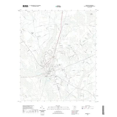
2020 Map of Kingstree
USGS Topo · Published 2020About this map
Kingstree serves as the focal point of this coastal plain survey, situated where the Black River is spanned by the Wallace D Conner Bridge. The town's layout reflects its role as the seat of local government, centered on the Williamsburg County Courthouse. The surrounding landscape is defined by extensive wetlands and swamp systems characteristic of the Lowcountry, including Flat Swamp, Law Swamp, and Boggy Swamp. To the north, the small settlement of Brockington sits near the Williamsburg Regional Airport. This 2020 data provides a clear view of the modern road network, including Sandy Bay Rd and Cotton Ln, while also preserving the locations of legacy sites like the Williamsburg Presbyterian Cem and McClary Cem. The presence of the Williamsburg Technical College indicates the town's contemporary educational infrastructure amidst its deep colonial roots.
Find a feature on this map
141 named features on this map. Tap any name to fly to it.
Don’t see what you’re looking for? This feature index may not catch every label — zoom into the map to look around manually.
Map Details
Editions of this 2020 Kingstree Map
This is the sole edition of this map. No revisions or reprints were ever made.
Other maps of this area

1946 · Hyman
USGS Topo · 1:62,500

1946 · Kingstree
USGS Topo · 1:62,500

1946 · Lake City
USGS Topo · 1:62,500

1946 · Indiantown
USGS Topo · 1:62,500

1949 · Georgetown
USGS Topo · 1:250,000

1967 · Georgetown
USGS Topo · 1:250,000

1974 · Georgetown
USGS Topo · 1:250,000

1986 · Kingstree
USGS Topo · 1:100,000
1990 · Hebron Crossroads
USGS Topo · 1:24,000
1990 · Lake City East
USGS Topo · 1:24,000