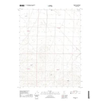
2018 Map of Kinkaid NW
USGS Topo · Published 2018About this map
Gillis Range peaks dominate the southern half of this Mineral County landscape, where deep drainages like Paymaster Canyon and Sheeps Head Canyon carve through the high desert. The terrain transitions in the north toward the open expanse of Buckley Flat and the confined Win-Wan Valley, illustrating the classic basin and range geography of the region. This 2018 survey by the U.S. Geological Survey shows a sparsely developed area defined by its natural topography rather than human settlement. Features such as Rand Ridge and the ephemeral Nugent Wash serve as primary landmarks for navigating this arid environment. The map captures a contemporary snapshot of public lands, primarily managed under the Bureau of Land Management's survey system.
Find a feature on this map
11 named features on this map. Tap any name to fly to it.
Don’t see what you’re looking for? This feature index may not catch every label — zoom into the map to look around manually.
Map Details
Editions of this 2018 Kinkaid NW Map
This is the sole edition of this map. No revisions or reprints were ever made.
Other maps of this area

1909 · Hawthorne
USGS Topo · 1:250,000

1911 · Hawthorne
USGS Topo · 1:250,000

1915 · Hawthorne
USGS Topo · 1:250,000

1948 · Walker Lake
USGS Topo · 1:250,000

1955 · Hawthorne
USGS Topo · 1:62,500

1957 · Walker Lake
USGS Topo · 1:250,000

1962 · Walker Lake
USGS Topo · 1:250,000

1964 · Walker Lake
USGS Topo · 1:250,000

1964 · Gillis Canyon
USGS Topo · 1:62,500
1979 · Copper Mtn.
USGS Topo · 1:24,000