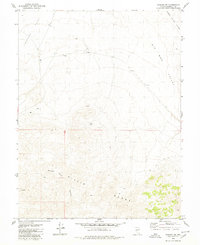
1979 Map of Kinkaid NW
USGS Topo · Published 1980About this map
The Gillis Range and Gabbs Valley Range dominate this Nevada landscape, revealing a remote terrain defined by high basins and isolated mining activity during the late 1970s. The map illustrates a sparse network of infrastructure centered around the extraction of mineral resources, marked by an isolated Prospect and several other Prospects scattered across the ridgelines. Movement through the area is restricted to a simple Jeep Trail, emphasizing the area's isolation from major thoroughfares.
Find a feature on this map
11 named features on this map. Tap any name to fly to it.
Don’t see what you’re looking for? This feature index may not catch every label — zoom into the map to look around manually.
Map Details
Editions of this 1979 Kinkaid NW Map
This is the sole edition of this map. No revisions or reprints were ever made.
Other maps of this area

1909 · Hawthorne
USGS Topo · 1:250,000

1911 · Hawthorne
USGS Topo · 1:250,000

1915 · Hawthorne
USGS Topo · 1:250,000

1948 · Walker Lake
USGS Topo · 1:250,000

1955 · Hawthorne
USGS Topo · 1:62,500

1957 · Walker Lake
USGS Topo · 1:250,000

1962 · Walker Lake
USGS Topo · 1:250,000

1964 · Walker Lake
USGS Topo · 1:250,000

1964 · Gillis Canyon
USGS Topo · 1:62,500
1979 · Copper Mtn.
USGS Topo · 1:24,000