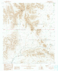
1990 Map of Kino Peak
USGS Topo · Published 1990About this map
Kino Peak stands as the high point in this remote corner of Pima County, rising above the complex volcanic landscape of the Bates Mountains. By the late 20th century, this area was defined by its protected status within the Organ Pipe Cactus National Monument, where the Organ Pipe Cactus Wilderness preserves the arid reaches of the Ajo Valley and the La Abra Plain. Evidence of previous human activity persists in the desert, notably at the Golden Bell Mine and various scattered Mine Shafts Prospects near the Puerto Blanco Mountains. Sparse water sources like Acuna Well, Bonita Well, and Dripping Springs highlight the critical infrastructure required for survival and industry in the Sonoran environment. Modern travel is marked by the winding route of Puerto Blanco Drive, which connects the southern flats to Roadside Park.
Find a feature on this map
18 named features on this map. Tap any name to fly to it.
Don’t see what you’re looking for? This feature index may not catch every label — zoom into the map to look around manually.
Map Details
Editions of this 1990 Kino Peak Map
This is the sole edition of this map. No revisions or reprints were ever made.
Other maps of this area

1953 · Ajo
USGS Topo · 1:250,000

1954 · Sonoyta
USGS Topo · 1:250,000

1957 · Ajo
USGS Topo · 1:250,000

1958 · Ajo
USGS Topo · 1:250,000

1962 · Ajo
USGS Topo · 1:250,000

1963 · Ajo
USGS Topo · 1:250,000

1963 · Lukeville
USGS Topo · 1:62,500

1963 · Quitobaquito Springs
USGS Topo · 1:62,500

1963 · Kino Peak
USGS Topo · 1:62,500

1963 · Lukeville
USGS Topo · 1:250,000