
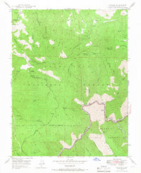
1947 Map of Kinsley
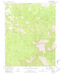
USGS Topo · Published 1988About this map
McCauley Ranch (Old Stage Station) sits at the northern edge of this Mariposa County landscape, marking a legacy of travel and transport in the western Sierra Nevada. Based on 1947 fieldwork, the topography captures the transition from the Stanislaus National Forest down toward the deep canyon of the Merced River. The river corridor is a focal point of activity and geology, featuring a Geological Exhibit and the Ferguson Dump near the water's edge.
Find a feature on this map
56 named features on this map. Tap any name to fly to it.
Don’t see what you’re looking for? This feature index may not catch every label — zoom into the map to look around manually.
Map Details
Editions of this 1947 Kinsley Map
3 editions found
Historical Maps of Mariposa County Through Time
134 maps found

1897 Yosemite
Mariposa County, CA

1900 Yosemite
Mariposa County, CA

1903 Yosemite
Mariposa County, CA

1909 Yosemite
Mariposa County, CA

1915 Owens Creek
Mariposa County, CA

1916 Merced Falls
Mariposa County, CA

1918 Owens Creek
Mariposa County, CA

1919 Indian Gulch
Mariposa County, CA

1919 Merced Falls
Mariposa County, CA

1920 Indian Gulch
Mariposa County, CA

1944 Merced Falls
Mariposa County, CA

1947 Ben Hur
Mariposa County, CA

1947 Buckhorn Peak
Mariposa County, CA

1947 Buckingham Mtn
Mariposa County, CA

1947 Feliciana Mtn.
Mariposa County, CA
1947 Kinsley
Mariposa County, CA

1947 Stumpfield Mtn.
Mariposa County, CA

1948 Ben Hur
Mariposa County, CA

1948 Buckhorn Peak
Mariposa County, CA

1948 Feliciana Mtn.
Mariposa County, CA

1948 Stumpfield Mtn.
Mariposa County, CA

1949 Buckhorn Peak
Mariposa County, CA

1949 Buckingham Mtn
Mariposa County, CA

1949 Kinsley
Mariposa County, CA

1954 Indian Gulch
Mariposa County, CA

1954 Merced Falls
Mariposa County, CA

1956 Yosemite
Mariposa County, CA

1962 Illinois Hill
Mariposa County, CA

1962 Indian Gulch
Mariposa County, CA

1962 Indian Gulch
Mariposa County, CA

1962 Merced Falls
Mariposa County, CA

1962 Merced Falls
Mariposa County, CA

1962 Owens Reservoir
Mariposa County, CA

1962 Penon Blanco Peak
Mariposa County, CA

1963 Owens Reservoir
Mariposa County, CA

1990 El Capitan
Mariposa County, CA

1990 Half Dome
Mariposa County, CA

1990 Mariposa Grove
Mariposa County, CA

1990 Merced Peak
Mariposa County, CA

1990 Tenaya Lake
Mariposa County, CA

1990 Yosemite Falls
Mariposa County, CA

1992 Buckingham Mtn
Mariposa County, CA

1992 El Capitan
Mariposa County, CA

1992 Feliciana Mtn.
Mariposa County, CA

1992 Half Dome
Mariposa County, CA

1992 Kinsley
Mariposa County, CA

1992 Mariposa Grove
Mariposa County, CA

1992 Merced Peak
Mariposa County, CA

1992 Tenaya Lake
Mariposa County, CA

1992 Yosemite Falls
Mariposa County, CA

1997 El Capitan
Mariposa County, CA

1997 Half Dome
Mariposa County, CA

1997 Merced Peak
Mariposa County, CA

1997 Tenaya Lake
Mariposa County, CA

1997 Yosemite Falls
Mariposa County, CA

1999 Illinois Hill
Mariposa County, CA

1999 Indian Gulch
Mariposa County, CA

1999 Owens Reservoir
Mariposa County, CA

2001 Buckhorn Peak
Mariposa County, CA

2001 Kinsley
Mariposa County, CA

2004 Buckingham Mountain
Mariposa County, CA

2004 El Capitan
Mariposa County, CA

2004 Feliciana Mountain
Mariposa County, CA

2004 Mariposa Grove
Mariposa County, CA

2004 Stumpfield Mountain
Mariposa County, CA

2012 Ben Hur
Mariposa County, CA

2012 Buckhorn Peak
Mariposa County, CA

2012 Buckingham Mountain
Mariposa County, CA

2012 El Capitan
Mariposa County, CA

2012 Feliciana Mountain
Mariposa County, CA

2012 Half Dome
Mariposa County, CA

2012 Illinois Hill
Mariposa County, CA

2012 Indian Gulch
Mariposa County, CA

2012 Kinsley
Mariposa County, CA

2012 Mariposa Grove
Mariposa County, CA

2012 Merced Falls
Mariposa County, CA

2012 Merced Peak
Mariposa County, CA

2012 Owens Reservoir
Mariposa County, CA

2012 Penon Blanco Peak
Mariposa County, CA

2012 Stumpfield Mountain
Mariposa County, CA

2012 Tenaya Lake
Mariposa County, CA

2012 Yosemite Falls
Mariposa County, CA

2015 Ben Hur
Mariposa County, CA

2015 Buckhorn Peak
Mariposa County, CA

2015 Buckingham Mountain
Mariposa County, CA

2015 El Capitan
Mariposa County, CA

2015 Feliciana Mountain
Mariposa County, CA

2015 Half Dome
Mariposa County, CA

2015 Illinois Hill
Mariposa County, CA

2015 Indian Gulch
Mariposa County, CA

2015 Kinsley
Mariposa County, CA

2015 Mariposa Grove
Mariposa County, CA

2015 Merced Falls
Mariposa County, CA

2015 Merced Peak
Mariposa County, CA

2015 Owens Reservoir
Mariposa County, CA

2015 Penon Blanco Peak
Mariposa County, CA

2015 Stumpfield Mountain
Mariposa County, CA

2015 Tenaya Lake
Mariposa County, CA

2015 Yosemite Falls
Mariposa County, CA

2018 Ben Hur
Mariposa County, CA

2018 Buckhorn Peak
Mariposa County, CA

2018 Buckingham Mountain
Mariposa County, CA

2018 El Capitan
Mariposa County, CA

2018 Feliciana Mountain
Mariposa County, CA

2018 Half Dome
Mariposa County, CA

2018 Illinois Hill
Mariposa County, CA

2018 Indian Gulch
Mariposa County, CA

2018 Kinsley
Mariposa County, CA

2018 Mariposa Grove
Mariposa County, CA

2018 Merced Falls
Mariposa County, CA

2018 Merced Peak
Mariposa County, CA

2018 Owens Reservoir
Mariposa County, CA

2018 Penon Blanco Peak
Mariposa County, CA

2018 Stumpfield Mountain
Mariposa County, CA

2018 Tenaya Lake
Mariposa County, CA

2018 Yosemite Falls
Mariposa County, CA

2021 Ben Hur
Mariposa County, CA

2021 Buckhorn Peak
Mariposa County, CA

2021 Buckingham Mountain
Mariposa County, CA

2021 El Capitan
Mariposa County, CA

2021 Feliciana Mountain
Mariposa County, CA

2021 Half Dome
Mariposa County, CA

2021 Illinois Hill
Mariposa County, CA

2021 Indian Gulch
Mariposa County, CA

2021 Kinsley
Mariposa County, CA

2021 Mariposa Grove
Mariposa County, CA

2021 Merced Falls
Mariposa County, CA

2021 Merced Peak
Mariposa County, CA

2021 Owens Reservoir
Mariposa County, CA

2021 Penon Blanco Peak
Mariposa County, CA

2021 Stumpfield Mountain
Mariposa County, CA

2021 Tenaya Lake
Mariposa County, CA

2021 Yosemite Falls
Mariposa County, CA

2023 Stumpfield Mountain
Mariposa County, CA