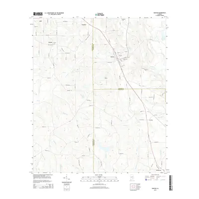
2014 Map of Kinston
USGS Topo · Published 2014About this map
The town of Kinston serves as a central hub on this 2014 survey, where Alabama State Route 189 and Route 52 converge amidst the undulating terrain of the Wiregrass region. This landscape is defined by its rural connectivity, with a dense network of timber and farm roads like Log Cabin Dr and Paper Co Rd threading through the pine-dominated landscape. The topography is shaped by the complex drainage systems of Flat Creek and Cripple Creek, which eventually feed toward the Pea River on the eastern edge. For genealogists, the map preserves the locations of numerous community anchors, including Beulah Cem, Saint Pauls Cem, and Harrison Cem. Scattered smaller settlements like Estothel, Lowery, and Earlytown reflect the enduring agricultural character of the borderlands where Coffee, Covington, and Geneva Counties meet.
Find a feature on this map
84 named features on this map. Tap any name to fly to it.
Don’t see what you’re looking for? This feature index may not catch every label — zoom into the map to look around manually.
Map Details
Editions of this 2014 Kinston Map
This is the sole edition of this map. No revisions or reprints were ever made.
Other maps of this area

1953 · Andalusia
USGS Topo · 1:250,000

1957 · Andalusia
USGS Topo · 1:250,000
1968 · Samson
USGS Topo · 1:24,000
1968 · Ino
USGS Topo · 1:24,000
1968 · Sellersville
USGS Topo · 1:24,000

1968 · Opp East
USGS Topo · 1:24,000
1969 · Hacoda
USGS Topo · 1:24,000
1969 · Kinston
USGS Topo · 1:24,000

1971 · Onycha
USGS Topo · 1:24,000
1971 · Florala
USGS Topo · 1:24,000