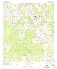
1969 Map of Kinston
USGS Topo · Published 1971About this map
Kinston serves as a central hub for this portion of southern Alabama, where the Louisville and Nashville railroad cuts a diagonal path through the countryside. The landscape is defined by the extensive Geneva State Forest, which dominates the southern half of the quadrangle. This area is heavily dissected by watercourses like Flat Creek and Indian Creek, suggesting a region historically reliant on timber and small-scale agriculture.
Find a feature on this map
36 named features on this map. Tap any name to fly to it.
Don’t see what you’re looking for? This feature index may not catch every label — zoom into the map to look around manually.
Map Details
Editions of this 1969 Kinston Map
2 editions found
Other maps of this area

1953 · Andalusia
USGS Topo · 1:250,000

1957 · Andalusia
USGS Topo · 1:250,000
1968 · Samson
USGS Topo · 1:24,000
1968 · Ino
USGS Topo · 1:24,000
1968 · Sellersville
USGS Topo · 1:24,000

1968 · Opp East
USGS Topo · 1:24,000
1969 · Hacoda
USGS Topo · 1:24,000

1971 · Onycha
USGS Topo · 1:24,000
1971 · Florala
USGS Topo · 1:24,000
1971 · Opp West
USGS Topo · 1:24,000