1906 Map of Kintla Lakes
USGS Topo · Published 1927About this map
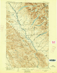
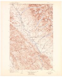
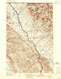
The Flathead River carves through this northern wilderness along the United States Dominion of Canada border, revealing a landscape defined by massive glaciers and early homesteads. At the time of this survey, the area within Glacier National Park was sparsely settled, centered around isolated outposts like Schoenburg Ranch and Cummings Ranch. Geographers R. H. Chapman and R. H. Sargent documented a complex network of peaks and water bodies, including the significant Kintla Lake and Bowman Lake chains. Evidence of early resource exploration appears at Butte Well and Kintla Well, while river crossings such as Henshaw Bridge provided critical links for travelers and the Rangers Cabin. The map captures the height of the glacial era in the region, naming numerous active ice fields like the Agassiz Glacier and Rainbow Glacier before their mid-century recession.
Find a feature on this map
119 named features on this map. Tap any name to fly to it.
Don’t see what you’re looking for? This feature index may not catch every label — zoom into the map to look around manually.
Map Details
Editions of this 1906 Kintla Lakes Map
4 editions found
Other maps of this area

1904 · Chief Mountain
USGS Topo · 1:125,000

1906 · Kintla Lakes
USGS Topo · 1:125,000

1913 · Stryker
USGS Topo · 1:125,000

1914 · Nyack
USGS Topo · 1:125,000

1916 · Stryker
USGS Topo · 1:125,000

1938 · Chief Mountain
USGS Topo · 1:125,000

1938 · Kintla Lakes
USGS Topo · 1:125,000

1943 · Kalispell
USGS Topo · 1:125,000

1957 · Kalispell
USGS Topo · 1:250,000

1960 · Kalispell
USGS Topo · 1:250,000