1906 Map of Kintla Lakes
USGS Topo · Published 1942About this map
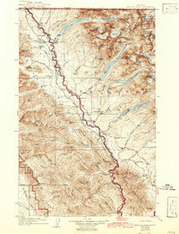
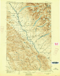
Flathead River carves a critical boundary through this high-altitude landscape, defining the western edge of Glacier National Park as it stood in the early twentieth century. This survey, updated with revisions from 1938, captures the transition of a frontier wilderness into a managed national preserve. While much of the terrain is defined by massive glacial troughs like Kintla Lake, Bowman Lake, and Logging Lake, the human footprint is visible in scattered homesteads and outposts. Isolated sites such as Brille Ranch, Cummings Ranch, and the Theo Christensen Ranch appear alongside the settlement at Polebridge. The map also details early administrative infrastructure, including several Ranger Sta locations and a network of trails revised by the National Park Service. The northern border is firmly established by the United States Dominion Of Canada line, which follows the jagged crests of the boundary mountains.
Find a feature on this map
120 named features on this map. Tap any name to fly to it.
Don’t see what you’re looking for? This feature index may not catch every label — zoom into the map to look around manually.
Map Details
Editions of this 1906 Kintla Lakes Map
4 editions found
Other maps of this area

1904 · Chief Mountain
USGS Topo · 1:125,000

1906 · Kintla Lakes
USGS Topo · 1:125,000

1913 · Stryker
USGS Topo · 1:125,000

1914 · Nyack
USGS Topo · 1:125,000

1916 · Stryker
USGS Topo · 1:125,000

1938 · Chief Mountain
USGS Topo · 1:125,000

1938 · Kintla Lakes
USGS Topo · 1:125,000

1943 · Kalispell
USGS Topo · 1:125,000

1957 · Kalispell
USGS Topo · 1:250,000

1960 · Kalispell
USGS Topo · 1:250,000