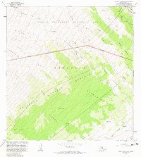
1981 Map of Kipuka Pakekake
USGS Topo · Published 1983About this map
Kapapala Forest Reserve and the southern reaches of Hawaii Volcanoes National Park define this volcanic landscape on the Island of Hawaii. The terrain is marked by extensive activity, with many areas labeled as Lava Flow and Lava Channel, particularly across the northern half of the survey. The eponymous Kipuka Pake Kake and neighboring Kipuka Loihi represent islands of older vegetation and soil surrounded by more recent basaltic flows, a characteristic geological pattern of the Mauna Loa slopes. To the south, the lushness of Pahuamimi and Ainapo contrasts with the starkness of the higher elevations. Scattered traces of human presence appear in the lower sections, including small settlements such as Maluikeao and Kauhiuhi, along with various 4wd tracks and a solitary Rain Shed that provided essential shelter in this remote environment.
Find a feature on this map
26 named features on this map. Tap any name to fly to it.
Don’t see what you’re looking for? This feature index may not catch every label — zoom into the map to look around manually.
Map Details
Editions of this 1981 Kipuka Pakekake Map
2 editions found
Other maps of this area

1921 · Kilauea
USGS Topo · 1:62,500

1924 · Kilauea
USGS Topo · 1:62,500

1927 · Kaohe
USGS Topo · 1:62,500

1928 · Mauna Loa
USGS Topo · 1:62,500

1930 · Humuula
USGS Topo · 1:62,500

1930 · Kaohe
USGS Topo · 1:62,500

1954 · Hawaii South
USGS Topo · 1:250,000

1954 · Hawaii North
USGS Topo · 1:250,000
1956 · Puu Ulaula
USGS Topo · 1:24,000
1956 · Kulani
USGS Topo · 1:24,000