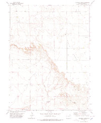
1978 Map of Kirchnavy Butte
USGS Topo · Published 1978About this map
Kirchnavy Butte dominates this corner of Logan County, marking a high point in a landscape defined by dramatic escarpments and canyon systems. The plateau of Peetz Table overlooks the surrounding terrain, where natural water sources like Dead Man Spring and Willow Spring provide critical relief in this semi-arid environment. The 1970s landscape shows a clear overlay of industrial activity across the drainage of Derby Creek, with numerous sites marked as Oil Well and Gas Well scattered throughout the sections. Canyons and landforms such as Martin Canyon, Bracht, and Beatt break the symmetry of the tableland, while Flattop Butte sits near the southern boundary. This map captures a moment when traditional ranching topography met the expanding footprint of the energy industry, as seen in the network of drill holes and wells following the local contours.
Find a feature on this map
16 named features on this map. Tap any name to fly to it.
Don’t see what you’re looking for? This feature index may not catch every label — zoom into the map to look around manually.
Map Details
Editions of this 1978 Kirchnavy Butte Map
This is the sole edition of this map. No revisions or reprints were ever made.
Other maps of this area

1951 · Padroni NW
USGS Topo · 1:24,000

1952 · Padroni
USGS Topo · 1:24,000

1954 · Sterling
USGS Topo · 1:250,000

1954 · Scottsbluff
USGS Topo · 1:250,000

1958 · Scottsbluff
USGS Topo · 1:250,000

1958 · Sterling
USGS Topo · 1:250,000

1972 · Easterly Airport
USGS Topo · 1:24,000

1972 · Potter SW
USGS Topo · 1:24,000

1972 · Potter SE
USGS Topo · 1:24,000
1978 · Chimney Canyons
USGS Topo · 1:24,000