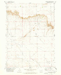
1978 Map of Chimney Canyons
USGS Topo · Published 1978About this map
Chimney Canyons define this corner of Logan County during the late 1970s, where the high plains terrain breaks into a series of dramatic erosional features like West Chimney and East Chimney. The landscape is a functional mix of cattle ranching and energy extraction, evidenced by an extensive Oil Field and numerous scattered Oil Wells across the northern half of the sheet. Educational and logistical infrastructure is sparse but present, anchored by the Rocky Buttes School and a remote Landing Strip.
Find a feature on this map
17 named features on this map. Tap any name to fly to it.
Don’t see what you’re looking for? This feature index may not catch every label — zoom into the map to look around manually.
Map Details
Editions of this 1978 Chimney Canyons Map
This is the sole edition of this map. No revisions or reprints were ever made.
Other maps of this area

1954 · Sterling
USGS Topo · 1:250,000

1954 · Scottsbluff
USGS Topo · 1:250,000

1958 · Scottsbluff
USGS Topo · 1:250,000

1958 · Sterling
USGS Topo · 1:250,000

1972 · Potter SW
USGS Topo · 1:24,000

1972 · Kimball SE
USGS Topo · 1:24,000

1972 · Potter SE
USGS Topo · 1:24,000

1977 · Dipper Spring
USGS Topo · 1:24,000

1977 · Avalo SE
USGS Topo · 1:24,000
1978 · Kirchnavy Butte
USGS Topo · 1:24,000