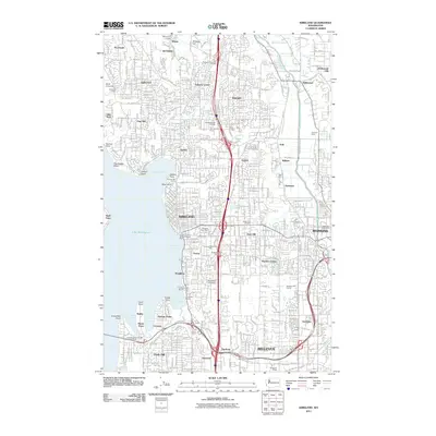
2011 Map of Kirkland
USGS Topo · Published 2011About this map
Lake Washington defines the western edge of this 2011 survey, a dense suburban landscape where the eastside cities of Kirkland, Bellevue, and Redmond converge. The topography is shaped by prominent rises like Norway Hill and Hollywood Hill, while the Sammamish River winds through the northeast corner past the community of Hollywood. This era of the region’s development is marked by established neighborhoods such as Finn Hill, Juanita, and Houghton, alongside specialized campuses including Bastyr University and Northwest University.
Find a feature on this map
70 named features on this map. Tap any name to fly to it.
Don’t see what you’re looking for? This feature index may not catch every label — zoom into the map to look around manually.
Map Details
Editions of this 2011 Kirkland Map
This is the sole edition of this map. No revisions or reprints were ever made.
Other maps of this area

1894 · Seattle
USGS Topo · 1:62,500

1895 · Snohomish
USGS Topo · 1:125,000

1897 · Seattle
USGS Topo · 1:125,000

1908 · Seattle
USGS Topo · 1:62,500

1909 · Seattle Special
USGS Topo · 1:62,500

1942 · Edmonds
USGS Topo · 1:62,500

1944 · Everett
USGS Topo · 1:62,500

1949 · Seattle North
USGS Topo · 1:24,000
1949 · Seattle South
USGS Topo · 1:24,000

1950 · Redmond
USGS Topo · 1:24,000