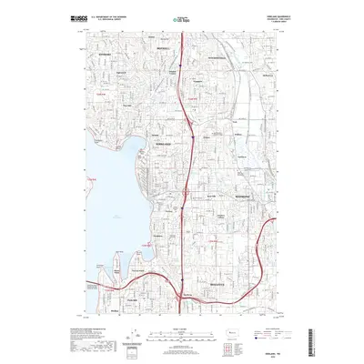
2020 Map of Kirkland
USGS Topo · Published 2020About this map
Lake Washington defines the western boundary of this coastal corridor, where the urban development of Kirkland and Redmond meets the eastern shores. The map captures a densely interwoven landscape of residential neighborhoods like Inglewood, Kingsgate, and Rose Hill, positioned along the major transit arteries connecting to Bellevue. Educational hubs such as Northwest University and Lake Washington Technical College are established landmarks, while the Sammamish River winds through the northern reach toward Bothell.
Find a feature on this map
65 named features on this map. Tap any name to fly to it.
Don’t see what you’re looking for? This feature index may not catch every label — zoom into the map to look around manually.
Map Details
Editions of this 2020 Kirkland Map
This is the sole edition of this map. No revisions or reprints were ever made.
Other maps of this area

1894 · Seattle
USGS Topo · 1:62,500

1895 · Snohomish
USGS Topo · 1:125,000

1897 · Seattle
USGS Topo · 1:125,000

1908 · Seattle
USGS Topo · 1:62,500

1909 · Seattle Special
USGS Topo · 1:62,500

1942 · Edmonds
USGS Topo · 1:62,500

1944 · Everett
USGS Topo · 1:62,500

1949 · Seattle North
USGS Topo · 1:24,000
1949 · Seattle South
USGS Topo · 1:24,000

1950 · Redmond
USGS Topo · 1:24,000