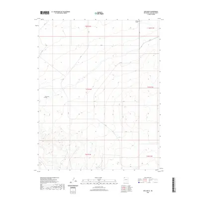
2020 Map of Kirtland SE
USGS Topo · Published 2020About this map
Ojo Amarillo Canyon cuts across the northeastern corner of this San Juan County landscape, providing a rare topographical focal point in a terrain defined by subtle drainage patterns and wide desert reaches. The hydrological network is centered on the Cottonwood Arroyo, which drains the western portion of the quadrangle. This 2020 edition reveals a sparse but deliberate infrastructure of local Bureau of Indian Affairs roads, such as N 4065 and N 4154, which follow the natural contours and section lines of the Public Land Survey System. The map documents the vast townships of t27n r14w and t28n r14w, illustrating the intersection of modern road management within the Shiprock Agency lands. For those tracing the evolution of Northwest New Mexico's land use, the placement of routes like N 4050 and N 4155 relative to the dry arroyos offers insight into the practical geography of the region.
Find a feature on this map
17 named features on this map. Tap any name to fly to it.
Don’t see what you’re looking for? This feature index may not catch every label — zoom into the map to look around manually.
Map Details
Editions of this 2020 Kirtland SE Map
This is the sole edition of this map. No revisions or reprints were ever made.
Other maps of this area

1889 · Chaco
USGS Topo · 1:250,000

1892 · Chaco
USGS Topo · 1:250,000

1927 · Sulphur Spring
USGS Topo · 1:96,000

1928 · Kirtland
USGS Topo · 1:125,000

1932 · Kirtland
USGS Topo · 1:125,000

1954 · Shiprock
USGS Topo · 1:250,000

1958 · Shiprock
USGS Topo · 1:250,000

1959 · Shiprock
USGS Topo · 1:250,000
1965 · Farmington South
USGS Topo · 1:24,000
1965 · Hugh Lake
USGS Topo · 1:24,000