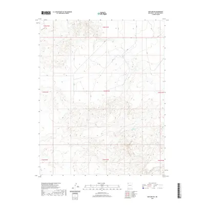
2020 Map of Kirtland SW
USGS Topo · Published 2020About this map
Chinde Wash dominates the northern reaches of this New Mexico landscape, winding through a complex network of canyons and ridges defined by a tight 10-foot contour interval. This modern topographic study reveals a high-desert environment where water sources are vital, specifically identifying Cottonwood Springs and the coded 13R-104 Spring. The presence of the Pinto Reroute in the northwest corner highlights recent modifications to the area's movement patterns. Organized by the Public Land Survey System, the map spans several township and range blocks including t27n r15w and t28n r15w, providing a clear structural framework for understanding the topography of the San Juan County region.
Find a feature on this map
12 named features on this map. Tap any name to fly to it.
Don’t see what you’re looking for? This feature index may not catch every label — zoom into the map to look around manually.
Map Details
Editions of this 2020 Kirtland SW Map
This is the sole edition of this map. No revisions or reprints were ever made.
Other maps of this area

1889 · Chaco
USGS Topo · 1:250,000

1892 · Chaco
USGS Topo · 1:250,000

1927 · Sulphur Spring
USGS Topo · 1:96,000

1928 · Kirtland
USGS Topo · 1:125,000

1932 · Kirtland
USGS Topo · 1:125,000

1954 · Shiprock
USGS Topo · 1:250,000

1958 · Shiprock
USGS Topo · 1:250,000

1959 · Shiprock
USGS Topo · 1:250,000
1966 · The Hogback North
USGS Topo · 1:24,000
1966 · Newcomb NE
USGS Topo · 1:24,000