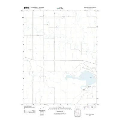
2012 Map of Kirwin Reservoir
USGS Topo · Published 2012About this map
Kirwin Reservoir dominates the southern landscape of this Phillips County region, formed by the impoundment of the N Fork Solomon River. The 2012 survey illustrates the irregular shoreline of the reservoir, specifically identifying Crappie Point and Bluegill Point as prominent landforms extending into the water. North of the lake, the terrain is defined by a series of north-south drainage systems, including Deer Cr, Big Cr, and Plum Cr, which carve through the agricultural grid.
Find a feature on this map
18 named features on this map. Tap any name to fly to it.
Don’t see what you’re looking for? This feature index may not catch every label — zoom into the map to look around manually.
Map Details
Editions of this 2012 Kirwin Reservoir Map
This is the sole edition of this map. No revisions or reprints were ever made.
Other maps of this area

1893 · Phillipsburg
USGS Topo · 1:125,000

1955 · Beloit
USGS Topo · 1:250,000

1959 · Beloit
USGS Topo · 1:250,000

1961 · Kirwin SE
USGS Topo · 1:24,000

1961 · Kirwin SW
USGS Topo · 1:24,000

1972 · Kirwin
USGS Topo · 1:24,000

1972 · Kirwin Reservoir
USGS Topo · 1:24,000

1972 · Phillipsburg South
USGS Topo · 1:24,000
1972 · Glade SE
USGS Topo · 1:24,000

1973 · Kensington
USGS Topo · 1:24,000