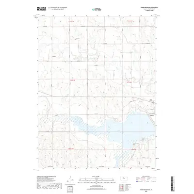
2018 Map of Kirwin Reservoir
USGS Topo · Published 2018About this map
Kirwin Reservoir dominates this landscape in Phillips County, formed by the impoundment of the North Fork Solomon River. The topography revealed in this 2018 survey shows a transition from the structured street grid of Kirwin to the expansive waters of the reservoir, punctuated by recreational landmarks like Bluegill Point and Crappie Point. The surrounding terrain is dissected by several drainages, including Big Cr and Deer Cr, which feed into the central basin. For those tracing local heritage, the map identifies Kirwin Cem and Hillsdale Cem, providing precise locations for family history research. North of the water, the Wyrill Farming Airport reflects the region's agricultural aviation needs, while a dense network of range and township roads—such as E Santa Fe Rd and E Xavier Rd—defines the rural land divisions characteristic of the Kansas plains.
Find a feature on this map
39 named features on this map. Tap any name to fly to it.
Don’t see what you’re looking for? This feature index may not catch every label — zoom into the map to look around manually.
Map Details
Editions of this 2018 Kirwin Reservoir Map
This is the sole edition of this map. No revisions or reprints were ever made.
Other maps of this area

1893 · Phillipsburg
USGS Topo · 1:125,000

1955 · Beloit
USGS Topo · 1:250,000

1959 · Beloit
USGS Topo · 1:250,000

1961 · Kirwin SE
USGS Topo · 1:24,000

1961 · Kirwin SW
USGS Topo · 1:24,000

1972 · Kirwin
USGS Topo · 1:24,000

1972 · Kirwin Reservoir
USGS Topo · 1:24,000

1972 · Phillipsburg South
USGS Topo · 1:24,000
1972 · Glade SE
USGS Topo · 1:24,000

1973 · Kensington
USGS Topo · 1:24,000