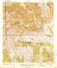
1943 Map of Kisatchie
USGS Topo · Published 1943About this map
Kisatchie National Forest dominates the landscape of this wartime survey, revealing a region defined by its timber industry and complex water network. The Red River and Gulf Railroad provides a primary industrial artery, cutting east-to-west through settlements like Kurthwood, Alco, and Hutton. The influence of the timber trade is further evidenced by several stretches of Old Logging Railroad Grade, showing how deep-woods access shaped the development of northern Louisiana.
Find a feature on this map
66 named features on this map. Tap any name to fly to it.
Don’t see what you’re looking for? This feature index may not catch every label — zoom into the map to look around manually.
Map Details
Editions of this 1943 Kisatchie Map
This is the sole edition of this map. No revisions or reprints were ever made.
Other maps of this area
1937 · Chopin SW
USGS Topo · 1:31,680
1937 · Chopin NW
USGS Topo · 1:31,680
1937 · Bellwood
USGS Topo · 1:31,680
1937 · Montgomery
USGS Topo · 1:62,500
1937 · Cloutierville
USGS Topo · 1:31,680
1937 · Cypress
USGS Topo · 1:31,680
1941 · Leesville
USGS Topo · 1:62,500
1941 · Slagle
USGS Topo · 1:62,500
1942 · Many
USGS Topo · 1:62,500
1942 · Florien
USGS Topo · 1:62,500