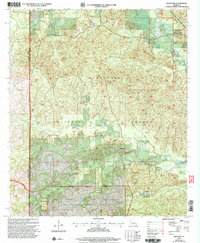
2003 Map of Kisatchie
USGS Topo · Published 2005About this map
Kisatchie and the surrounding pine woods of the Kisatchie National Forest define this area of Natchitoches Parish. The landscape is marked by a clear distinction between the forested public lands and the expansive Fort Polk Military Reservation, which includes the Peason Ridge Artillery Range to the south. This military presence, established decades prior to this update, occupies a significant portion of the terrain, designated as a Restricted Use Area where artillery fire and training exercises take precedence over typical forest activities.
Find a feature on this map
31 named features on this map. Tap any name to fly to it.
Don’t see what you’re looking for? This feature index may not catch every label — zoom into the map to look around manually.
Map Details
Editions of this 2003 Kisatchie Map
This is the sole edition of this map. No revisions or reprints were ever made.
Other maps of this area

1937 · Bellwood
USGS Topo · 1:31,680

1937 · Cypress
USGS Topo · 1:31,680

1942 · Many
USGS Topo · 1:62,500

1942 · Florien
USGS Topo · 1:62,500

1942 · Kisatchie
USGS Topo · 1:62,500

1943 · Many
USGS Topo · 1:62,500

1943 · Kisatchie
USGS Topo · 1:62,500

1943 · Provencal
USGS Topo · 1:62,500

1944 · Florien
USGS Topo · 1:62,500

1945 · Provencal
USGS Topo · 1:62,500