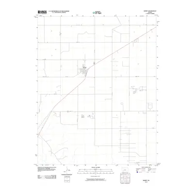
2010 Map of Kismet
USGS Topo · Published 2010About this map
Kismet serves as the central hub of this agricultural landscape in Seward County, characterized by a meticulous grid of rural roads and section lines. The settlement is positioned along a primary transportation corridor, with residential streets and local infrastructure concentrated near the intersection of Co Rd 11 and Kismet Rd. The surrounding terrain is defined by its industrial-scale farming layout, visible through the precise orientation of routes like Triple Rd and Rodeo Ave. A notable geographic marker is the Fense Line running south towards Meade Lake Rd, illustrating the transition between managed parcels. This 2010 survey provides a clear view of the high plains settlement pattern, showing how the local road network, including Co Rd S, facilitates movement through the expansive ranch and farm lands of southwestern Kansas.
Find a feature on this map
22 named features on this map. Tap any name to fly to it.
Don’t see what you’re looking for? This feature index may not catch every label — zoom into the map to look around manually.
Map Details
Editions of this 2010 Kismet Map
This is the sole edition of this map. No revisions or reprints were ever made.
Other maps of this area

1955 · Dodge City
USGS Topo · 1:250,000

1958 · Dodge City
USGS Topo · 1:250,000

1959 · Dodge City
USGS Topo · 1:250,000

1963 · Plains
USGS Topo · 1:24,000

1963 · Kismet SE
USGS Topo · 1:24,000

1963 · Kismet NE
USGS Topo · 1:24,000

1968 · Plains SW
USGS Topo · 1:24,000

1968 · Liberal NE
USGS Topo · 1:24,000

1968 · Sublette SE
USGS Topo · 1:24,000
1971 · Kismet
USGS Topo · 1:24,000