
1963 Map of Kismet SE
USGS Topo · Published 1964About this map
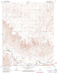
The Cimarron River winds through the southern reaches of this landscape, cutting through the high plains at the border of Kansas and Oklahoma. This 1963 survey captures a region defined by its ranching heritage and emerging energy economy, where the XI Ranch and XIT Ranch occupy large tracts of the terrain. The northern plateau is dotted with a Friends Ch and family-named landmarks like Twin Hills, while the land to the south drops sharply into a series of drainages, including Wolf Canyon and Keefe Canyon. These breaks in the plains reveal geological features such as Table Mesa. Economic activity is represented by dozens of distributed Oil Wells and Gas Wells, showing the mid-century intensification of resource extraction across the High Plains of Meade County.
Find a feature on this map
14 named features on this map. Tap any name to fly to it.
Don’t see what you’re looking for? This feature index may not catch every label — zoom into the map to look around manually.
Map Details
Editions of this 1963 Kismet SE Map
2 editions found
Other maps of this area

1892 · Meade
USGS Topo · 1:125,000

1954 · Perryton
USGS Topo · 1:250,000

1955 · Dodge City
USGS Topo · 1:250,000

1958 · Perryton
USGS Topo · 1:250,000

1958 · Dodge City
USGS Topo · 1:250,000

1959 · Dodge City
USGS Topo · 1:250,000

1963 · Kismet NE
USGS Topo · 1:24,000

1963 · Lake Larrabee
USGS Topo · 1:24,000

1963 · Irish Flats
USGS Topo · 1:24,000

1970 · Mocane NW
USGS Topo · 1:24,000