
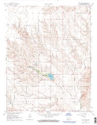
1963 Map of Lake Larrabee
USGS Topo · Published 1964About this map
Meade County State Park serves as a central oasis in this mid-century portrait of southwestern Kansas, where the waters of Lake Larrabee break the surrounding High Plains terrain. The landscape is defined by the intersection of four township districts—West Plains, Meade Center, Cimarron, and Odee—divided by the winding course of Crooked Creek and its seasonal drainages like Stumpie Arroyo and Skunkie Arroyo.
Find a feature on this map
21 named features on this map. Tap any name to fly to it.
Don’t see what you’re looking for? This feature index may not catch every label — zoom into the map to look around manually.
Map Details
Editions of this 1963 Lake Larrabee Map
2 editions found
Other maps of this area

1892 · Meade
USGS Topo · 1:125,000

1955 · Dodge City
USGS Topo · 1:250,000

1958 · Dodge City
USGS Topo · 1:250,000

1959 · Dodge City
USGS Topo · 1:250,000

1962 · Irish Flats NE
USGS Topo · 1:24,000

1962 · Irish Flats SE
USGS Topo · 1:24,000

1963 · Plains
USGS Topo · 1:24,000

1963 · Kismet SE
USGS Topo · 1:24,000

1963 · Kismet NE
USGS Topo · 1:24,000

1963 · Irish Flats
USGS Topo · 1:24,000