
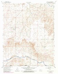
1963 Map of Irish Flats
USGS Topo · Published 1964About this map
The Cimarron River winds across the southern reaches of this landscape, carving a distinct valley through the open terrain of Irish Flats and Odee. In the early 1960s, this border region between Kansas and Oklahoma was characterized by an expanding energy infrastructure, evidenced by numerous Oil Well and Gas Well sites scattered across the plains. Local life and history are anchored by landmarks such as Blair Chapel and its adjacent Cem, providing a window into the rural community near the state line.
Find a feature on this map
23 named features on this map. Tap any name to fly to it.
Don’t see what you’re looking for? This feature index may not catch every label — zoom into the map to look around manually.
Map Details
Editions of this 1963 Irish Flats Map
2 editions found
Other maps of this area

1892 · Meade
USGS Topo · 1:125,000

1954 · Perryton
USGS Topo · 1:250,000

1955 · Dodge City
USGS Topo · 1:250,000

1958 · Perryton
USGS Topo · 1:250,000

1958 · Dodge City
USGS Topo · 1:250,000

1959 · Dodge City
USGS Topo · 1:250,000

1962 · Irish Flats NE
USGS Topo · 1:24,000

1962 · Irish Flats SE
USGS Topo · 1:24,000

1963 · Kismet SE
USGS Topo · 1:24,000

1963 · Kismet NE
USGS Topo · 1:24,000