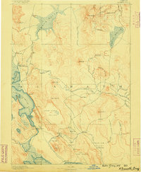
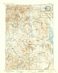
1889 Map of Klamath
USGS Topo · Published 1889About this map
Linkville serves as a focal point in this southern Oregon landscape, situated at the critical junction between Lower Klamath Lake and the wetlands leading toward Tule Lake. Surveyed in the mid-1880s, the map reveals a region defined by its vast water systems and early government outposts, including Ft. Klamath and the dual administrative centers at Klamath Agency and Yainax Agency. The drainage of the Williamson River and Sprague River dictates the settlement pattern, with small communities like Bonanza and Dairy established in the fertile basins of Poe Valley and Langells Valley.
Find a feature on this map
78 named features on this map. Tap any name to fly to it.
Don’t see what you’re looking for? This feature index may not catch every label — zoom into the map to look around manually.
Map Details
Editions of this 1889 Klamath Map
This is the sole edition of this map. No revisions or reprints were ever made.
Other maps of this area

1886 · Alturas
USGS Topo · 1:250,000

1886 · Modoc Lava Bed
USGS Topo · 1:250,000

1886 · Shasta
USGS Topo · 1:250,000
1891 · Ashland
USGS Topo · 1:250,000

1892 · Modoc Lava-Bed
USGS Topo · 1:250,000

1892 · Alturas
USGS Topo · 1:250,000
1893 · Ashland
USGS Topo · 1:250,000
1894 · Klamath
USGS Topo · 1:250,000

1894 · Shasta
USGS Topo · 1:250,000
1897 · Ashland
USGS Topo · 1:250,000