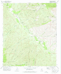
1972 Map of Klondyke
USGS Topo · Published 1988About this map
Klondyke serves as the focal point of this 1970s survey, situated along the banks of Aravaipa Creek in Graham County. The settlement is defined by its remote proximity to the Santa Teresa Mts and Coronado National Forest, where high elevations like Pinnacle Ridge and Quartz Hill tower over the drainage systems. Resource extraction is evident through the presence of the Dog Water Mine and Quinn Mine, while local infrastructure is marked by a remote Landing Strip and the Buford Road. The landscape is etched with deep drainages such as Laurel Canyon and Rattlesnake Canyon, which rely on scattered water sources like Haby Spring and Salty Tank. Genealogists may find particular interest in the Klondyke Cem, which provides a specific location for local family history research in this arid canyon environment.
Find a feature on this map
34 named features on this map. Tap any name to fly to it.
Don’t see what you’re looking for? This feature index may not catch every label — zoom into the map to look around manually.
Map Details
Editions of this 1972 Klondyke Map
4 editions found
Other maps of this area

1938 · Galiuro Mts
USGS Topo · 1:48,000

1938 · Klondyke
USGS Topo · 1:48,000

1940 · Sierra Bonita Ranch
USGS Topo · 1:62,500

1942 · Sierra Bonita Ranch
USGS Topo · 1:62,500

1943 · Galiuro Mts
USGS Topo · 1:62,500

1943 · Klondyke
USGS Topo · 1:62,500

1943 · Sierra Bonita Ranch
USGS Topo · 1:62,500

1944 · Jackson Mtn.
USGS Topo · 1:62,500

1946 · Jackson Mtn.
USGS Topo · 1:62,500

1956 · Tucson
USGS Topo · 1:250,000