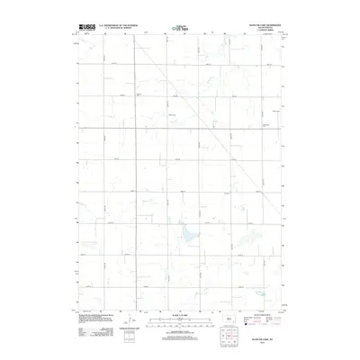
2012 Map of Kloucek Lake
USGS Topo · Published 2012About this map
Kloucek Lake and its surrounding prairie landscape define this part of Yankton County during the early 21st century. The terrain is organized by a strict section-line road grid, where north-south routes like 425th Ave and 427th Ave intersect with east-west corridors such as 296th St and 300th St. This systematic division of the land highlights the agricultural heritage of South Dakota, with the natural drainage provided by Prairie Cr and Beaver Cr meandering through the structured fields.
Find a feature on this map
19 named features on this map. Tap any name to fly to it.
Don’t see what you’re looking for? This feature index may not catch every label — zoom into the map to look around manually.
Map Details
Editions of this 2012 Kloucek Lake Map
This is the sole edition of this map. No revisions or reprints were ever made.
Other maps of this area
1898 · Olivet
USGS Topo · 1:125,000

1955 · Sioux City
USGS Topo · 1:250,000

1955 · Sioux Falls
USGS Topo · 1:250,000
1957 · Menno
USGS Topo · 1:24,000
1957 · Scotland
USGS Topo · 1:24,000
1958 · Sioux City
USGS Topo · 1:250,000

1958 · Sioux Falls
USGS Topo · 1:250,000
1959 · Sioux City
USGS Topo · 1:250,000
1978 · Tripp SE
USGS Topo · 1:24,000
1978 · Tabor NE
USGS Topo · 1:24,000
Featured Places
- Lesterville Township, SD
- Odessa Township, SD
- Scotland Township, SD
- Lincoln Township, SD
- Yankton County, SD