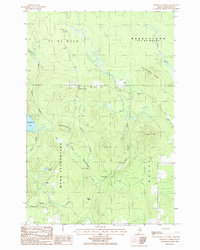
1986 Map of Knowles Corner
USGS Topo · Published 1986About this map
Knowles Corner serves as the primary crossroads in this portion of Aroostook County, situated at the junction of Route 212 and several mountain ridges. This 1986 provisional survey captures a landscape defined by the commercial timber and waterway networks of Northern Maine, notably the West Branch Mattawamkeag River. The river's path is marked by features like Four Foot Pitch, Upper Falls, and Lower Falls, while the presence of Jackson Sluice points to the historical management of water for log driving or local milling.
Find a feature on this map
30 named features on this map. Tap any name to fly to it.
Don’t see what you’re looking for? This feature index may not catch every label — zoom into the map to look around manually.
Map Details
Editions of this 1986 Knowles Corner Map
This is the sole edition of this map. No revisions or reprints were ever made.
Other maps of this area

1935 · Howe Brook
USGS Topo · 1:48,000

1937 · Smyrna Mills
USGS Topo · 1:62,500

1939 · Howe Brook
USGS Topo · 1:62,500

1940 · Island Falls
USGS Topo · 1:62,500

1940 · Oxbow
USGS Topo · 1:62,500

1942 · Island Falls
USGS Topo · 1:62,500

1942 · Oxbow
USGS Topo · 1:62,500

1954 · Howe Brook
USGS Topo · 1:62,500

1954 · Presque Isle
USGS Topo · 1:250,000

1955 · Smyrna Mills
USGS Topo · 1:62,500