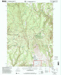
1999 Map of Knox Mountain
USGS Topo · Published 2002About this map
Malheur National Forest dominates this high-altitude landscape along the border of Grant and Harney Counties. The terrain is defined by dramatic peaks and deep drainages, centering on Knox Mountain and Antelope Mountain, the latter topped by the Antelope LO Lookout and an associated communication facility. This environment was shaped by a complex network of seasonal water sources and early livestock management infrastructure. Numerous named springs, including Marksbury Spring, Miller and Jackson Spring, and Moffitt Spring, provide a record of local land use and possible family holdings in a region where water was the primary driver of movement. Evidence of seasonal rangeland activity is clear at Ott Cow Camp, while the presence of the Tamarack Reservoir and Tuck Reservoir indicates intentional water catchment systems designed to sustain life and livestock in the higher elevations.
Find a feature on this map
51 named features on this map. Tap any name to fly to it.
Don’t see what you’re looking for? This feature index may not catch every label — zoom into the map to look around manually.
Map Details
Editions of this 1999 Knox Mountain Map
This is the sole edition of this map. No revisions or reprints were ever made.
Other maps of this area

1908 · Ironside Mountain
USGS Topo · 1:125,000

1955 · Burns
USGS Topo · 1:250,000

1955 · Canyon City
USGS Topo · 1:250,000

1958 · Burns
USGS Topo · 1:250,000

1959 · Burns
USGS Topo · 1:250,000

1959 · Canyon City
USGS Topo · 1:250,000

1961 · Logan Valley
USGS Topo · 1:62,500

1968 · Drewsey
USGS Topo · 1:62,500

1968 · Van
USGS Topo · 1:62,500

1970 · Flag Prairie
USGS Topo · 1:62,500