
1961 Map of Logan Valley
USGS Topo · Published 1963About this map
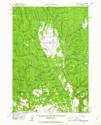
Logan Valley is a high-altitude basin within the Malheur National Forest, where the transition from mid-century ranching to forest management is clearly visible. The landscape is defined by its abundance of named springs and seasonal camps, reflecting a heavy reliance on water and timber. Functional structures like the OK Truck Barn, Summit Prairie Truck Barns, and the Lake Creek Guard Sta suggest a rugged working environment coordinated by the state and federal government. Settlement history is preserved in the form of cabins, such as the Davenport Cabin and Kimberling Cabin, while the Frost Mill (Site) marks the location of earlier industrial activity. The presence of several cow camps and the Summit Prairie railroad line indicates an integrated economy of grazing and logging that sustained the region through the early 1960s.
Find a feature on this map
113 named features on this map. Tap any name to fly to it.
Don’t see what you’re looking for? This feature index may not catch every label — zoom into the map to look around manually.
Map Details
Editions of this 1961 Logan Valley Map
2 editions found
Other maps of this area

1908 · Ironside Mountain
USGS Topo · 1:125,000

1940 · John Day
USGS Topo · 1:62,500

1943 · John Day
USGS Topo · 1:62,500

1955 · Burns
USGS Topo · 1:250,000

1955 · Canyon City
USGS Topo · 1:250,000

1958 · Burns
USGS Topo · 1:250,000

1959 · Burns
USGS Topo · 1:250,000

1959 · Canyon City
USGS Topo · 1:250,000

1959 · Prairie City
USGS Topo · 1:62,500

1961 · Calamity Butte
USGS Topo · 1:62,500