
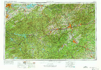
1957 Map of Knoxville
USGS Topo · Published 1966About this map
Great Smoky Mountains National Park and the high peaks of the Blue Ridge dominate this mid-century view of East Tennessee and Western North Carolina. The map documents the region's transport network as Interstate 40 was developing, shown alongside established routes like the Blue Ridge Parkway and the Southern RR. Urban centers such as Knoxville and Asheville contrast with the protected wilderness of the Nantahala National Forest and Pisgah National Forest.
Find a feature on this map
102 named features on this map. Tap any name to fly to it.
Don’t see what you’re looking for? This feature index may not catch every label — zoom into the map to look around manually.
Map Details
Editions of this 1957 Knoxville Map
4 editions found
Other maps of this area

1883 · Morristown
USGS Topo · 1:125,000

1886 · Knoxville
USGS Topo · 1:125,000

1886 · Dahlonega
USGS Topo · 1:125,000

1886 · Walhalla
USGS Topo · 1:125,000

1888 · Ellijay
USGS Topo · 1:125,000

1888 · Pickens
USGS Topo · 1:125,000

1891 · Cowee
USGS Topo · 1:125,000

1891 · Roan Mountain
USGS Topo · 1:125,000

1892 · Dahlonega
USGS Topo · 1:125,000

1892 · Walhalla
USGS Topo · 1:125,000